
Paxi is the smallest of the seven major islands in the Ionian chain, with an area of 25.32 square kilometres (length 8 km., breadth 4 km). The island lies seven nautical miles to the south of Corfu, quite close to the coast of Epirus: the channel between Paxi and Parga is only 12 nautical miles wide. There are ferry departures to Corfu town and Lefkimmi, and also to Patra, Igoumenitsa, Amfilochia and Preveza, while during the summer month's launches ply back and forth to Parga. The population of Paxi is 2,400 - most of them employed in the cultivation of the olive crop and in fishing. Tourism is not particularly highly developed, and Paxi continues to be an ideal place for those who look forward to quiet holidays far from the bustle of the popular resorts.
Paxi is an island of great natural beauty; its dense covering of pines, olives and vines, its deeply indented coastline, its steep rocky cliffs and its sea-caves combine to produce a landscape of idyllic charm. The interior of the island is relatively flat - the highest 'peak', Agios (Agios (Ayios)) Isavros, is only 217 metres above sea level - making it ideal for walking or cycling. Walkers will find numerous paths leading down to isolated beaches. The road network is well-organised and buses run to most of the villages.


To the north-west of Corfu, at distances of between 10 and 14 miles from its coast, lie a group of islands called the Diapontia which are the most westerly territory of Greece, situated where the Ionian Sea becomes the Adriatic. The largest of the islands are Mathraki, Ereikousa and Othoni, little Greek paradises where time seems to have come to a nearhalt and where life flows slowly and peacefully by. All three are verdant, with olives and cypresses as the commonest trees. The very few inhabitants of the islands are fishermen, farmers and shepherds. Visitors are an even rarer sight, and this has done much to preserve the authenticity of the islands. In the summer months, caiques and launches ply to and from the islands, operating out of the harbours along the north coast of Corfu, but in the winter such sailings are few and far between and the Diapontia islands return to their isolation. Little is known of the ancient history of the islands, and such information as we have comes from the written sources: the poet Lycophron (320-250 BC), the historian Pliny (23-79 AD), and the lexicographer Hesychius (fifth century AD). They seem to have been uninhabited in Byzantine times, and it was not until the Venetians ruled on Corfu that fresh settlers arrived, from Paxi and Epirus. During the period of the British protectorate, the Diapontia were places of exile for those who advocated the unification of the Ionian Islands with the rest of Greece. After unification actually took place in I864, the island's communities were formed into the Municipality of Diapontia, whose chief settlement is Ammos on Othoni. Today, each island is a separate administrative entity of its own, and there are some 600 permanent residents.
Mathraki is three nautical miles from the coast of Corfu, the closest point to it being the beach of Arillas.It has an area of 3.5 square kilometres and around 140 inhabitants, who are employed in fishing and harvesting the olives of the island. In earlier times, this was an island of sailors, owning some 30 sailing ships, but the dwindling population brought sea-faring activities to an end.
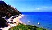

Othoni is the westernmost point in Greece, lying 7.5 miles from the north-west coast of Corfu and 43 nautical miles from Cape Otranto in Italy. The island has an area of nine square kilometres and two large villages, Ano and Kato Chorio (Ammos), with about 100 inhabitants. The beach near Ammos, the chief settlement, has both sand and pebbles, while there is a sandy beach at Aspri Ammos.
